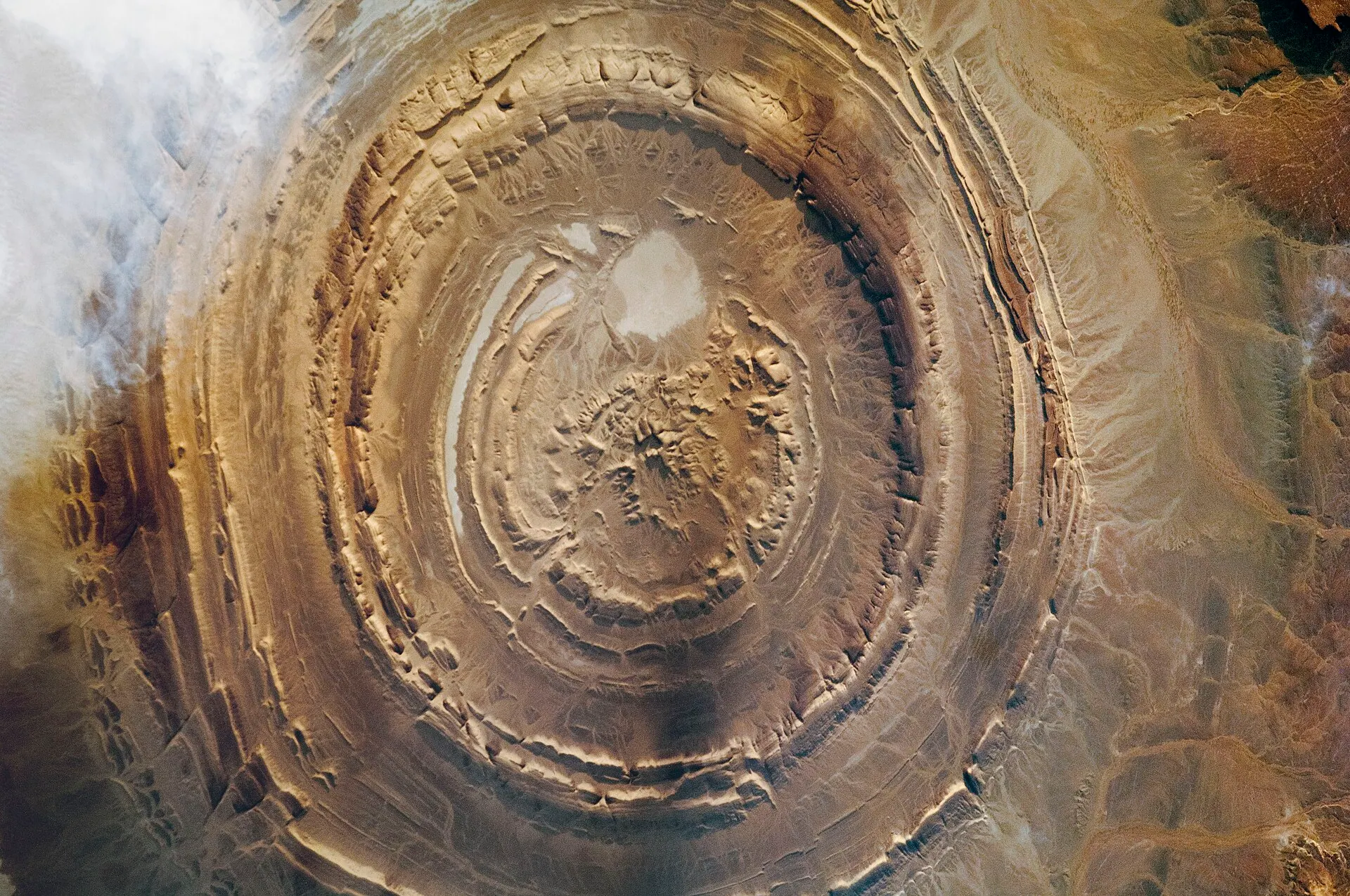
Astronaut photograph of the Richat Structure in Mauritania taken from the International Space Station: concentric rings of eroded rock about 40 km across in the Sahara.
NASA / WIKIMEDIA COMMONS / PUBLIC DOMAIN

Richat Structure (Eye of the Sahara)

Eye of the Sahara · Guelb er Richât · Richat Structure Atlantis claim
MISIDENTIFICATION

Mainstream consensus: Well-studied Saharan geologic dome; Atlantis identification is speculative media, not classics or field archaeology consensus.

Share this page
Short answer

The Richat Structure is a real eroded geologic dome in Mauritania often mislabeled online as Plato’s Atlantis rings. Geology explains the concentric bands; Greek dialogues still live in prose, not as a Saharan city blueprint carved by gods or aliens.

Mainstream view

Richat is a terrestrial geologic structure - an eroded dome whose rings look designed from orbit. It is not an archaeological Atlantis. Plato’s dialogues remain literary; no Bronze Age harbor city matching Critias has been excavated there.

Alternative claim

Internet Atlantis hunters argue the Eye of the Sahara is Plato’s concentric island capital, often adding suppressed archaeology or advanced-tech overlays.

Mauritania’s Richat Structure looks like a target painted on the Sahara. From orbit the concentric bands hypnotize; up close they are rock layers shaped by uplift and erosion. Geologists model a terrestrial dome. Viral maps overlay Plato’s Atlantis because circles look cinematic, not because excavators found harbor walls waiting under sand.

Field timelines sit awkwardly beside “Atlantis sank yesterday” storytelling. Igneous and erosional histories do not read as a Bronze Age metro still waiting with Critias’s checklist intact. Orbital photos sell mystery; thin sections sell physics. Peer-reviewed geology of the Eye of the Sahara is public - absence of published Atlantis archaeology is not a conspiracy proof.

Plato embedded Atlantis in hubris fables long before satellites. Ancient listeners debated meaning; modern thumbnails debate coordinates. Matching dialogues to any crater or dome is geography theater. No primary ancient map pairs Plato’s island with the Mauritanian bull’s-eye; the link is modern media, not classical cartography.

For the wider candidate circus, see Atlantis Theories and other legendary lands such as Mu or Lemuria. Those pages keep literary traditions and fringe overlays on separate shelves - the same discipline Richat needs.

Surveys find Saharan deep time without drowned porticos matching Atlantis checklists. Concentric resemblance is pattern-matching; excavation would need harbor walls, canals, and dating, not just a pretty ring from the International Space Station. Awe here is planetary geology.

Tourist flights and documentary voiceovers love the silhouette because it looks designed. Design language in rock can be false friends. Differential erosion carves rings when hard and soft beds alternate around a dome; that recipe needs no canals and no kings. Comparing Richat to Plato’s nested rings is visual rhyme, not stratigraphic proof.

The Eye of the Sahara earns wonder without borrowing Plato’s plot. Earth’s eye stays natural and stunning - and remains poor homework for Critias when the assignment is archaeology rather than orbital aesthetics. Keep the NASA photos for geology class and the dialogues for philosophy class; mixing the syllabi is how thumbnails invent lost capitals.

Photos and illustrations

Mix of rights-cleared documentary stills and AI illustrations (labeled).

The Richat Structure seen from the ISS (Expedition 30), MauritaniaCredit: NASA / Wikimedia Commons / Public domain
The Richat Structure photographed from Apollo 9 (1969), MauritaniaCredit: NASA, processed by James Stuby / Wikimedia Commons / Public domain
Richat Structure atmosphere (AI illustration)AI illustration for reference only

Key debates and stories

Attributed discovery narratives, debates, and claim histories from named sources. Links open the originals; AnomalyWiki does not verify these claims.

Claims vs mainstream

The claim

Richat’s rings are Plato’s Atlantis capital proven from space.

Mainstream view

Concentric resemblance is pattern-matching. Geology models uplift and erosion; excavators have not published a matching Bronze Age port city.

The claim

Ancient maps secretly labeled Richat as Atlantis.

Mainstream view

No primary ancient map pairs Plato’s island with the Mauritanian dome. The link is modern thumbnail geography.

The claim

Geologists hide harbor walls and canals.

Mainstream view

Peer-reviewed geology of Richat is public; absence of published Atlantis archaeology is not a conspiracy proof.

Timeline

  1. 1960s–1970sOrbital photography popularizes the concentric “Eye of the Sahara” silhouette.Source: Satellite and astronaut photography archives
  2. late 20th–early 21st centuryGeologists publish formation models emphasizing dome uplift, intrusion, and differential erosion.Source: Geologic literature on the Richat Structure
  3. 2010s–2020sSocial media and documentary channels revive Richat-as-Atlantis overlays tied to Plato readings.Source: Popular Atlantis media critiques

FAQ

Is the Richat Structure Atlantis?

Geology and classical scholarship reject that identification. No Bronze Age city matching Plato’s capital has been excavated at Richat.

What formed the concentric rings?

Dome uplift and differential erosion of layered rock - a terrestrial geologic history, not harbor engineering.

Why do people connect it to Plato?

From orbit the circles look designed, and Plato describes concentric canals. Visual rhyme is not archaeological proof.

Where should I read about Atlantis properly?

Start with Plato’s dialogues and modern reception history - see our Atlantis Theories entry - before treating any satellite bull’s-eye as Critias made literal.