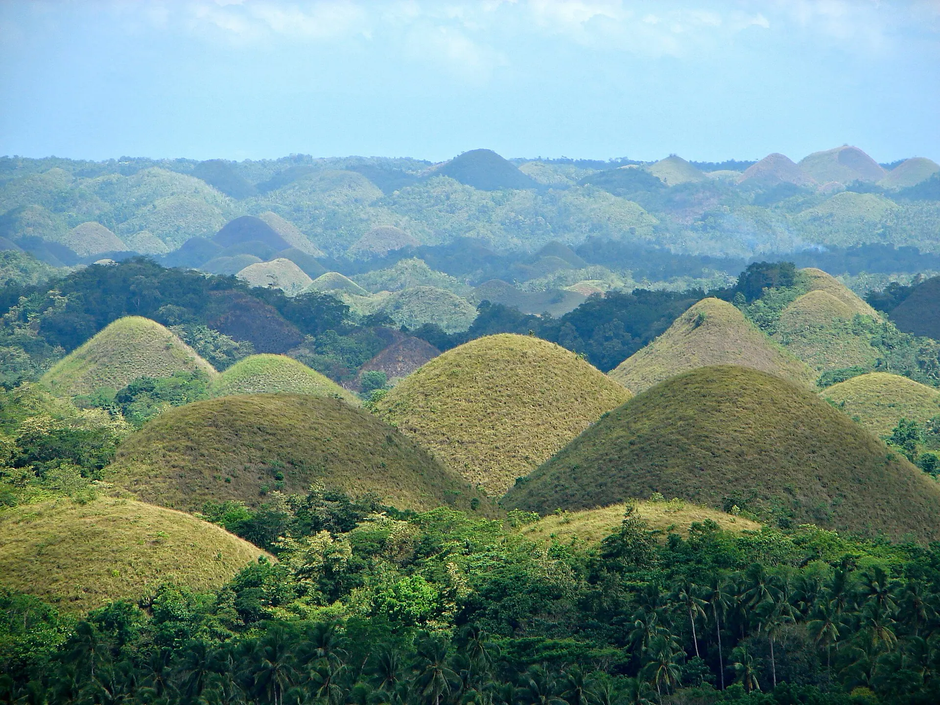
Overview of the Chocolate Hills in Bohol, Philippines
P199 / WIKIMEDIA COMMONS / CC BY-SA 3.0

Chocolate Hills

Chocolate Hills Natural Monument · Carmen hills · Haycock Hills
SCIENTIFICALLY EXPLAINED

Mainstream consensus: A verified karst landform shaped by marine limestone uplift and tropical erosion; the giant legends are Boholano folklore running alongside the geology, not a rival explanation competing with it.

Share this page
Short answer

Bohol's Chocolate Hills are roughly 1,776 near-identical limestone cones across Carmen, Batuan, and Sagbayan that turn cocoa-brown each dry season. Geologists call them cockpit karst, carved from uplifted Pliocene coral limestone. Boholano legend blames a heartbroken giant named Arogo; the real sculptor was rainfall working on porous rock for over a million years.

Location and access

The hills sit in central Bohol, Philippines, spread mainly across the towns of Carmen, Batuan, and Sagbayan, with outliers reaching Bilar, Valencia, and Sierra Bullones. The standard panorama stop is the Chocolate Hills Complex in Carmen (approximately 9.83 degrees N, 124.14 degrees E), where a staffed viewing deck sits atop about 220 steps.

Most visitors arrive by rental vehicle or organized tour from Tagbilaran or Panglao, a trip of roughly two hours each way. The complex charges an entrance fee and includes a small restaurant and souvenir stalls. Mornings offer gentler light and smaller crowds; the brown coloration peaks during the dry season but is never guaranteed on a fixed calendar.

History and legend

Boholano oral tradition explained the landscape long before any scientist arrived. One tale credits a giant named Arogo, who fell in love with a mortal woman, Aloya; when she died, his tears dried into mounds that became the hills. A rival story blames two giants who threw mud at each other for days until they collapsed from exhaustion, leaving the mess behind.

Science entered the picture in 1924, when geologist R.E. Dickerson published the first paper interested in the formation's origin and W.D. Smith's parallel survey counted 1,268 cones, calling them "Haycock Hills." The name most people use today is younger still: German geologist Frithjof Voss, studying the cones through aerial photographs in the late 1960s, nicknamed them "Chocolate Hills" in a 1970 paper after their dry-season color, and tourism operators picked up the name soon after.

Geologically, the hills are hundreds of meters of Pliocene coral limestone, uplifted above sea level by tectonic activity common to the Philippines' patchwork of small plates, then dissolved and sculpted by rainfall and groundwater into a near-uniform cone shape geologists call cockpit karst. No volcanic rock, ash layer, or evidence of a sudden catastrophic event has ever turned up among the cones, which rules out the dramatic "overnight formation" theories that occasionally circulate online. The Arogo tears legend and the two-giants mud fight remain the two best-known Boholano accounts, running as cultural explanations alongside, not against, that documented karst record.

Related places and beings

The Chocolate Hills share a shelf with other landscapes that look engineered until geology explains them: Zhangjiajie's sandstone pillars, Socotra's isolated flora, Pamukkale's travertine terraces, Racetrack Playa's moving stones, and Fly Geyser's accidental mineral cone. Cross-category, the Nazca Lines offer a useful contrast: another landscape feature that attracts fantastical origin stories despite a well-documented, human-and-geology explanation.

In popular culture

The Chocolate Hills appear constantly in Philippine tourism campaigns, travel television, and the national 1,000-peso banknote-era imagery associated with Bohol. The 2024 UNESCO Global Geopark designation has renewed attention to the site as a scientific showcase rather than only a photo backdrop. The 1988 National Geologic Monument declaration and 1997 Proclamation No. 1037 both treat the hills as a protected natural landform rather than an open scientific mystery, and local tourism material now leans on that documented status as much as on the giant-tears legend.

Photos and illustrations

Mix of rights-cleared documentary stills and AI illustrations (labeled).

Chocolate Hills conical mounds overviewCredit: P199 / Wikimedia Commons / CC BY-SA 3.0
Chocolate Hills landscape near CarmenCredit: Wolfgang Hägele / Wikimedia Commons / CC BY-SA 4.0
Rolling Chocolate Hills terrainCredit: Vyacheslav Argenberg / Wikimedia Commons / CC BY 4.0
Illustrative scene for Chocolate HillsAI illustration for reference only

Visiting

loading map…

The Chocolate Hills Complex viewing deck in Carmen is reached by about 220 steps; an entrance fee applies, with a restaurant and souvenir stalls at the top. Allow roughly two hours from Tagbilaran by road, usually paired with the Loboc River and a tarsier sanctuary stop. Confirm current fees and access rules with Bohol tourism before travel.

Legend vs history: Documented geology dates the limestone to the Pliocene and credits roughly a million years of rainfall and groundwater dissolving uplifted coral reef into near-identical mounds. The name "Chocolate Hills" itself is a 1970 scientific nickname, coined by German geologist Frithjof Voss after studying the cones by aerial photograph; Boholano legend had already explained the same landscape as a heartbroken giant's tears or two giants' mud fight, long before any geologist arrived.

Reports and stories

Attributed reports, haunt claims, and discovery narratives from named sources. Links open the originals; AnomalyWiki does not verify these claims.

Claims vs mainstream

The claim

A heartbroken giant's tears (or two giants' mud fight) formed the hills.

Mainstream view

Geologists trace the cones to Pliocene coral limestone uplifted by tectonic movement, then carved into near-identical cockpit karst by rainfall and groundwater over roughly a million years; no giants are required by the rock record.

The claim

The hills are too perfectly symmetrical to have formed naturally.

Mainstream view

Homogeneous limestone porosity and uniform tropical karstification conditions produce regular cockpit-karst cones. A comparable field exists in Java, Indonesia, which makes Bohol's hills unusual in scale and regularity but not geologically unique.

The claim

A volcanic eruption or sudden catastrophic shift created the mounds overnight.

Mainstream view

No volcanic rock or ash layer has ever turned up among the hills. The limestone composition and erosion record instead point to gradual coral-reef uplift followed by millions of years of weathering, not a single violent event.

Timeline

  1. 1924Geologist R.E. Dickerson publishes the first scientific interest in the formation's genesis, while W.D. Smith's survey the same year counts 1,268 cones and labels them "Haycock Hills."Source: Dickerson 1924, Philippine Journal of Science; Smith 1924 survey
  2. 1970German geologist Frithjof Voss, studying the mounds through aerial photographs, nicknames them "Chocolate Hills" for their dry-season color; the tourism industry adopts the name soon after.Source: Voss 1970, cited in Acta Carsologica and Wondermondo karst literature
  3. 1988-06-18The Philippine government declares the formation the country's third National Geologic Monument.Source: UNESCO World Heritage tentative-list entry for Chocolate Hills Natural Monument
  4. 1997-07-01President Fidel V. Ramos signs Proclamation No. 1037, formally reserving the roughly 1,776 hills across Carmen, Batuan, Sagbayan, Bilar, Valencia, and Sierra Bullones as the Chocolate Hills Natural Monument.Source: Proclamation No. 1037 (LawPhil)
  5. 2024Bohol becomes the Philippines' first UNESCO Global Geopark, with the Chocolate Hills named its flagship geological site.Source: Municipality of Carmen tourism office

FAQ

What are the Chocolate Hills?

Roughly 1,776 grass-covered limestone cones, each 30 to 120 meters tall, spread across Carmen, Batuan, and Sagbayan on Bohol island. They are a cockpit-karst landform carved from uplifted Pliocene coral limestone, not a man-made or volcanic feature.

How many Chocolate Hills are there?

Proclamation No. 1037 (1997) counts about 1,776 hills, while W.D. Smith's original 1924 survey counted 1,268; the difference comes down to survey method and which low mounds get included.

Why do the hills turn brown?

Grass cover on the cones dries out during the dry season (roughly December to May), turning cocoa-brown; the same grass is green through the wetter months.

Who named them "Chocolate Hills"?

German geologist Frithjof Voss coined the nickname in a 1970 paper after studying the cones by aerial photograph; tourism operators adopted it soon after.

Can tourists visit the hills?

Yes. The Chocolate Hills Complex in Carmen has a staffed viewing deck reached by about 220 steps, with an entrance fee, restaurant, and souvenir stalls.

Do geologists take the giant legend seriously?

No. It is folklore running alongside the science. Dickerson's and Smith's 1924 surveys, and decades of follow-up karst research, document a natural coral-limestone origin.