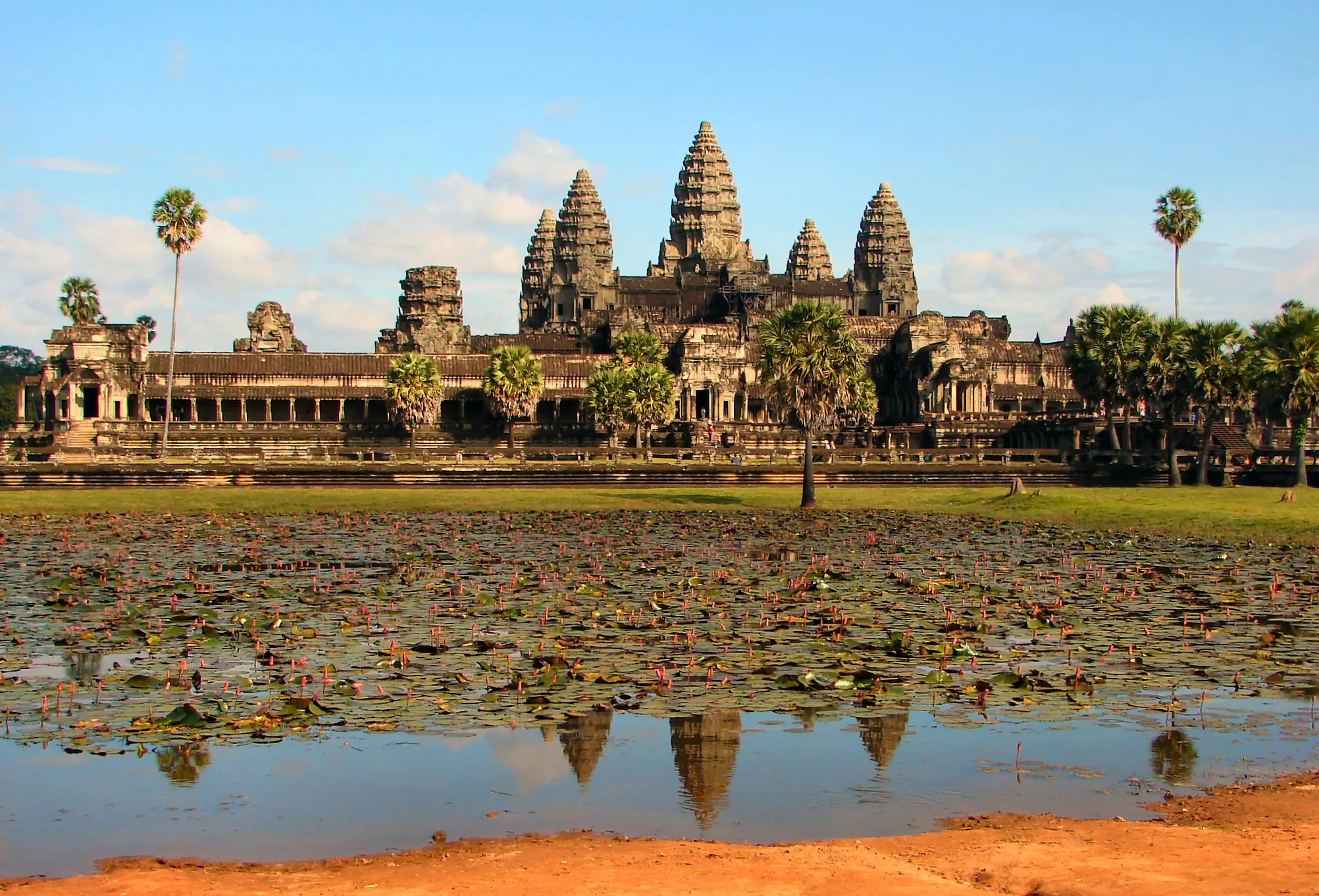
Angkor Wat's central temple towers reflected in its surrounding moat, Siem Reap, Cambodia.
WIKIMEDIA COMMONS CONTRIBUTOR

Khmer Empire and Angkor

Angkor · Angkor Wat · Khmer Empire
ARCHAEOLOGICAL

Mainstream consensus: Extensively excavated, lidar-mapped, and UNESCO-listed capital with continuous Khmer authorship documented in Sanskrit and Khmer inscriptions.

Share this page
Short answer

Angkor was the hydraulic megacity capital of the Khmer Empire, built around temple-mountains like Angkor Wat from the 9th to 15th centuries CE. Lidar surveys since 2012 revealed a low-density urban sprawl far larger than tourists ever walked, while drought-then-flood climate swings help explain why the canal-fed capital eventually emptied out.

Mainstream view

Angkor was a planned capital built and continuously modified by Khmer kings, engineered around an enormous network of barays (reservoirs), canals, and moats that supported rice agriculture and monumental temple construction for over five centuries.

Alternative claim

Some popular media frames Angkor as a "lost city" rediscovered by Europeans or hints the hydraulic network required non-period technology.

Angkor earns "megacity" honestly. At its height the Khmer capital spread engineered water across a landscape of barays, moats, and canals that irrigated rice fields and moved stone for temple construction on a scale unmatched in medieval Southeast Asia. Jayavarman II's 802 CE founding ritual started a dynasty of builder-kings; Suryavarman II's Angkor Wat and Jayavarman VII's walled Angkor Thom followed as the skyline's two loudest chapters.

The "lost city" framing says more about European travel writing than about Angkor itself. Henri Mouhot's 1860s dispatches thrilled Paris, but Buddhist monks had tended Angkor Wat the entire time - there was no rediscovery, just a new audience.

What genuinely surprised modern researchers came from the sky. Lidar surveys that Damian Evans led from 2012 onward stripped away jungle canopy digitally and revealed grid-patterned neighborhoods, shrine mounds, and canal extensions sprawling far past the temple core - a low-density urban footprint that roughly tripled Angkor's known size and reframed it as one of the pre-industrial world's largest cities by land area.

The empire's end reads less like collapse and more like strain breaking a system built for a different climate. Tree-ring records from Vietnamese cypress trees show decades-long megadroughts in the 14th century, followed by intense monsoon flooding - a drought-then-deluge sequence that researchers argue overwhelmed canals engineered for steadier rainfall. Political pressure compounded it: Ayutthaya's 1431 sack of Angkor accelerated a shift of Khmer power toward the Mekong delta and modern Phnom Penh.

Peers facing their own hydraulic-engineering strain include the Maya Classic collapse and monumental jungle-reclaimed sites like Nan Madol. The licensed Angkor Wat photo belongs here because the moat and towers are the clearest surviving argument for Khmer engineering ambition.

Angkor never fully emptied - smaller communities and religious use persisted around the temples for centuries. What ended was the capital's role as the empire's administrative center, a slow political and hydraulic unwinding that lidar and tree rings are still helping specialists date more precisely.

Documentary photos

Rights-cleared documentary stills and serious reference images. These are not AI illustrations.

Angkor Wat, Khmer Empire capitalCredit: Wikimedia Commons contributor

Key debates and stories

Attributed discovery narratives, debates, and claim histories from named sources. Links open the originals; AnomalyWiki does not verify these claims.

Claims vs mainstream

The claim

Angkor was a "lost city" that Europeans rediscovered in the jungle.

Mainstream view

Local Khmer communities and Buddhist monks maintained and used Angkor Wat continuously; Henri Mouhot's 1860s accounts popularized it in Europe but did not "find" an abandoned ruin.

The claim

The temples required technology beyond medieval Khmer capability.

Mainstream view

Inscriptions, quarry sites, and construction-phase studies document period sandstone quarrying, elephant and canal transport, and labor organization consistent with the empire's resources.

The claim

Angkor's hydraulic network was mythical or purely ceremonial.

Mainstream view

Lidar and excavation confirm a functioning engineered landscape of barays, canals, and moats supporting agriculture and urban water management at vast scale.

The claim

A single catastrophic event ended Angkor overnight.

Mainstream view

Tree-ring climate data and textual records point to a drawn-out sequence - decades of megadrought followed by intense monsoon flooding - that strained and damaged the water system over time.

Timeline

  1. 802 CEJayavarman II declares himself universal monarch, founding the unified Khmer Empire.Source: Khmer inscriptional record
  2. 1113–1150 CESuryavarman II builds Angkor Wat as a temple-mausoleum dedicated to Vishnu.Source: Angkor Wat inscriptions and art-historical dating
  3. late 12th–early 13th centuryJayavarman VII expands the capital with Angkor Thom and the Bayon temple after sacking by the Champa.Source: Khmer Empire chronologies
  4. 1431Ayutthaya forces sack Angkor, accelerating the shift of Khmer political power toward Phnom Penh.Source: Southeast Asian historical records
  5. 2012–2016Lidar surveys led by Damian Evans reveal vast low-density urban sprawl surrounding the temple core.Source: Journal of Archaeological Science lidar publications

FAQ

Who built Angkor?

Successive Khmer kings, beginning with Jayavarman II in 802 CE, built and expanded Angkor over more than five centuries.

Was Angkor really "lost" in the jungle?

No. Local Buddhist communities maintained Angkor Wat continuously; 1860s European accounts popularized it abroad without "discovering" an abandoned city.

How big was Angkor really?

Lidar surveys from 2012 onward revealed a sprawling low-density urban landscape far larger than the temple core most visitors see.

Why did Angkor decline?

Researchers point to a combination of warfare, political shifts, and climate swings - decades of drought followed by severe flooding that damaged the water system.

What is Angkor Wat?

A temple-mausoleum built under Suryavarman II around 1113-1150 CE, dedicated originally to the Hindu god Vishnu before later Buddhist use.

Is Angkor still used today?

Yes - it remains an active Buddhist religious site and a UNESCO World Heritage Site drawing millions of visitors.